


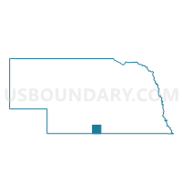
Orleans Precinct, Harlan County, Nebraska
About
Outline

Summary
| Unique Area Identifier | 613254 |
| Name | Orleans Precinct |
| County | Harlan County |
| State | Nebraska |
| Area (square miles) | 107.15 |
| Land Area (square miles) | 107.04 |
| Water Area (square miles) | 0.12 |
| % of Land Area | 99.89 |
| % of Water Area | 0.11 |
| Latitude of the Internal Point | 40.13259500 |
| Longtitude of the Internal Point | -99.46020590 |
Maps

Graphs
Select a template below for downloading or customizing gragh for Orleans Precinct, Harlan County, Nebraska


Neighbors
Neighoring Voting District (by Name) Neighboring Voting District on the Map
- East Alma Precinct, Harlan County, NE
- Granite Township Voting District, Phillips County, KS
- Huntley and Ragan Precinct, Harlan County, NE
- Long Island Township Voting District, Phillips County, KS
- Oxford Precinct, Harlan County, NE
- Stamford Precinct, Harlan County, NE
- West Alma Precinct, Harlan County, NE
Top 10 Neighboring County Subdivision (by Population) Neighboring County Subdivision on the Map
- Orleans township, Harlan County, NE (483)
- Emerson township, Harlan County, NE (277)
- Sappa township, Harlan County, NE (265)
- Long Island township, Phillips County, KS (226)
- Alma township, Harlan County, NE (190)
- Scandinavia township, Harlan County, NE (133)
- Reuben township, Harlan County, NE (61)
- Washington township, Harlan County, NE (61)
- Albany township, Harlan County, NE (59)
- Spring Grove township, Harlan County, NE (59)
Top 10 Neighboring Place (by Population) Neighboring Place on the Map
Top 10 Neighboring Unified School District (by Population) Neighboring Unified School District on the Map
- Holdrege Public Schools, NE (6,994)
- Southern Valley Schools, NE (2,895)
- Alma Public Schools, NE (1,885)
- Wilcox-Hildreth Public Schools, NE (1,470)
- Northern Valley Unified School District 212, KS (897)
- Loomis Public Schools, NE (788)
Top 10 Neighboring State Legislative District Lower Chamber (by Population) Neighboring State Legislative District Lower Chamber on the Map
Top 10 Neighboring State Legislative District Upper Chamber (by Population) Neighboring State Legislative District Upper Chamber on the Map
Top 10 Neighboring 111th Congressional District (by Population) Neighboring 111th Congressional District on the Map
Top 10 Neighboring Census Tract (by Population) Neighboring Census Tract on the Map
Top 10 Neighboring 5-Digit ZIP Code Tabulation Area (by Population) Neighboring 5-Digit ZIP Code Tabulation Area on the Map
- 68949, NE (6,567)
- 67661, KS (3,483)
- 68920, NE (1,446)
- 68967, NE (1,142)
- 68966, NE (674)
- 68977, NE (342)
- 67647, KS (256)